Monday, August 10, 2015
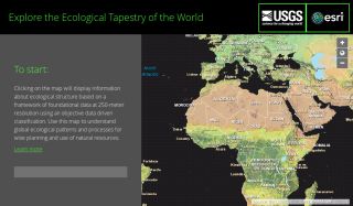
The First Ecological Land Units Map of the World http://esriurl.com/EcoTapestry Green Files Subject Tracer™
posted by Marcus Zillman |
4:57 AM
archives
subject tracers™
Contact Marcus
Marcus P. Zillman's Web Site Home Marcus P. Zillman's Blog Home Marcus P. Zillman Blog Archives Internet Alerts Marcus P. Zillman Internet Speaker Marcus P. Zillman Internet Consultant Marcus P. Zillman Internet Tutor Abbreviated Bio Blogger Profile White Papers Virtual Private Library™ Awareness Watch™ Monthly Newsletter Zillman Monthly Columns Archives LinkSeries Publications Survivor's Manual for The New Economy Research Resources Online Guide Internet Privacy and Security Resources Entrepreneurial Links 101 Market Intelligence Resources Current Awareness Monitors, Alerts and Information Traps Internet MiniGuides™ SourceSeries™ Internet Research Workshops What Is the Deep Web - A Podcast Inteview Deep Web Research and Discovery Resources 2013 Web Guide for the New Economy eGreenBot - Your Search Engine for Green Resources eHealthcareBot - Your Search Engines for Healthcare Resources eFinancialBot - Your Global Financial Search Engine eMarketingBot - Your Search Engine for Marketing Resources August 2013 Column - Auction Resources On the Internet July 2013 Column - HealthcareBots and Subject Directories June 2013 Column - Tutorial Resources and Sites on the Internet May 2013 Column - Journalism Resources on the Internet April 2013 Column - Grid, Distributed, and Cloud Computing Resources Primer March 2013 Column - Theology Online Resources February 2013 Column - Information Futures and Prediction Markets January 2013 Column - Managing Information Overload Resources 2013 December 2012 Column - ShoppingBots and Online Shopping 2013 November 2012 Column - Online Games Sites and Resources 2013 October 2012 Column - Statistics Resources and Big Data on the Internet September 2012 Column - Privacy Resources and Sites On the Internet August 2012 Column - Healthcare Online Resources 2012 July 2012 Column - Business Intelligence Resources On the Internet June 2012 Column - Finding People Resources and Sites on the Internet May 2012 Column - Discovery Resources for Navigating the New Economy April 2012 Column - Searching the Internet - A Primer March 2012 Column - Directory of Directories February 2012 Column - Data Mining and Web Data Extractors 2012 January 2012 Column - Entrepreneurial Resources 2012 December 2011 Column - How To Determine Information Quality and Competency: Resources, Sources and Sites November 2011 Column - Financial Internet Sources 2012 October 2011 Column - Journalist's Resources On the Internet September 2011 Column - Finding Experts by Using the Internet August 2011 Column - Student Research Resources July 2011 Column - Tools for Online Knowledge Discovery June 2011 Column - Elder Online Resources May 2011 Column - Online Grant Resources April 2011 Column - Semantic Web Research Resources March 2011 Column - Artificial Intelligence Resources On the Internet February 2011 Column - Bot and Intelligent Agent Research Resources On the Internet January 2011 Column - Peer to Peer (P2P) Resources December 2010 Column - ShoppingBots and Online Shopping Resources 2011 November 2010 Column - Online Knowledge Discovery Resources and Sites October 2010 Column - Internet Experts September 2010 Column - Healthcare Resources On the Internet 2010 August 2010 Column - eReference Resources July 2010 Column - Employment Online Resources June 2010 Column - Astronomy Resources Online May 2010 Column - Internet Demographics April 2010 Column - International Trade Resources 2010 March 2010 Column - Tutorial Resources 2010 February 2010 Column - Agriculture Resources 2010 January 2010 Column - Accessibility Resources 2010 December 2009 Column - ShoppingBots and Online Shopping 2010 November 2009 Column - Online Games Resources 2010 October 2009 Column - Privacy Resources 2010 September 2009 Column - Educational Resources for Twitter, SMS and Text Messaging August 2009 Column - 2010 The New Economy Analytics, Resources and Alerts July 2009 Column - Web Data Extractors Sites and Resources June 2009 Column - ChatterBots Sites and Resources May 2009 Column - Online Games Resources April 2009 Column - Biological Informatics Resources March 2009 Column - Anti-Virus, Anti-Hoax, Anti-Myth, Anti-Fraud, and Anti-Spam Resources February 2009 Column - New Economy Resources January 2009 Column - Peer To Peer Resources December 2008 Column - ShoppingBots and Online Shopping 2009 November 2008 Column - Statistics Resources October 2008 Column - Green Files September 2008 Column - Employment Resources Available Over the Internet August 2008 Column - Financial Sources Available Over the Internet July 2008 Column - World Wide Web Reference Resources June 2008 Column - Script and Code Resourcs May 2008 Column - Searching the Internet April 2008 Column - Data Mining and Web Extraction Resources On the Internet March 2008 Column - Grid Resources On the Internet February 2008 Column - Finding People Resources and Sites January 2008 Column - Online Entrepreneurial Resources 2008 December 2007 Column - Shopping Bots and Online Shopping Resources 2008 November 2007 Column - Reference Resources October 2007 Column - eCommerce Resources September 2007 Column - Peer To Peer (P2P) Search Engines and Resources August 2007 Column - Student Research Resources July 2007 Column - Healthcare Resources On the Internet June 2007 Column - Finding Experts By Using the Internet May 2007 Column - Journalism Resources On the Internet April 2007 Column - Grant Resources On the Internet March 2007 Column - Bot Research Resources On the Internet February 2007 Column - Auction Resources On the Internet January 2007 Column - Directory Resources On the Internet December 2006 Column - ShoppingBots and Online Shopping Resources 2007 November 2006 Column - Genealogy Resources On the Internet October 2006 Column - Privacy Resources On the Internet September 2006 Column - Games Resources August 2006 Column - Biotechnology Resources July 2006 Column - Biological Informatics Resources June 2006 Column - Astronomy Resources May 2006 Column - Business Intelligence Resources April 2006 Column - Agriculture Resources March 2006 Column - Accessibility Resources February 2006 Column - Social Informatics Resources January 2006 Column - Artificial Intelligence Resources December 2005 Column - ShoppingBots and Online Shopping 2006 November 2005 Column - Elder Resources October 2005 Column - Entrepreneurial Resources September 2005 Column - Employment Resources August 2005 Column - ChatterBots July 2005 Column - Military Resources June 2005 Column - Knowledge Discovery Resources May 2005 Column - Semantic Web Research Resources April 2005 Column - Prediction Markets and Information Futures March 2005 Column - Tutorial Resources February 2005 Column - Information Quality Resources and Sources January 2005 Column - World Wide Web Reference White Paper: eReference Library Link Toolkit White Paper: Finding Experts By Using the Internet White Paper: Healthcare Bots and Subject Directories White Paper: Business Intelligence Online Resources White Paper: Knowledge Discovery Resources 2012 White Paper: Academic and Scholar Search Engines and Sources White Paper: Online Research Browsers White Paper: Online Research Tools White Paper: Online Social Networking White Paper: Web Data Extractors White Paper: Bots, Blogs and News Aggregators White Paper: Searching the Internet White Paper: Current Awareness Discovery Tools on the Internet White Paper: Using the Internet As a Dynamic Resource Tool for Knowledge Discovery White Paper: Web Guide for the New Economy Information Traps listen to marcus™ Watch Marcus™ Workshops By Marcus™ Links By Marcus™ Smarter Bots Information Futures Markets Prediction Markets Internet Experts List Anti-Virus, Anti-Hoax, Anti-Myths, Anti-Spam Sites Internet Demographics Student Research Deep Web Research Knowledge Discovery Bot Research Healthcare Resources Research Resources Statistics Resources Biological Informatics Business Intelligence Resources eCommerce Resources Directory Resources ShoppingBots ChatterBots Finding People Genealogy Resources Privacy Resources Astronomy Resources Information Quality Resources Outsourcing/Offshoring Information and Resources Agriculture Resources Theology Resources Financial Sources Reference Resources Data Mining Resources Employment Resources Auction Resources Games Resources Artificial Intelligence Resources Grant Resources Grid Resources Elder Resources Tutorial Resources Entrepreneurial Resources Script Resources World Wide Web Reference Social Informatics Military Resources Accessibility Resources Biotechnology Resources Journalism Resources Green Files New Economy Analytics, Resources and Alerts International Trade Resources Intrapreneurial Resources Directory of Fact Checkers AnswerSpot Contact Marcus Feedjit Live Blog Stats © 2000 - 2018 Marcus P. Zillman, M.S., A.M.H.A.